Smokey Hollow was a vibrant, self-sustaining African American community situated a few blocks east of the Capitol Complex in downtown Tallahassee, in the shadow of Florida's seat of power. The neighborhood's history forces a rethinking of narratives about the government's use of eminent domain on marginalized communities in the modern era.
The Birth of Smokey Hollow

After the Civil War, Tallahassee sought to diversify its economy, transitioning from plantations and cash crops to manufacturing. As a result, the south side of Tallahassee became home to plants for the manufacture of window sashes, doors, furniture, crates, lumber, blinds, iron foundries, and more. The railroad yards on Gaines Street and the businesses that developed along the railroad South of downtown provided jobs for the influx of freedmen and their descendants who remained in the area after the War.
The neighborhood was established in the 1890s in an area east of the Capitol, now the site of Cascades Park. The name Smokey Hollow emerged as a nickname stemming from the persistent haze of smoke from residents' chimneys, combined with effluvium from a nearby municipal incinerator that settled in the low-lying area. Smokey Hollow remained a predominantly African American community due to the Jim Crow Era practices of racial segregation. Before its destruction, the neighborhood spanned about 85 acres.
Beginning to Thrive

By the 1940s, Smokey Hollow had grown into a thriving, self-sustaining community. Despite segregation's limitations, the neighborhood established its own grocery stores, churches, juke joints, schools, auto repair shops, laundries, and barber shops. The neighborhood featured rows of shotgun houses, a style of home common in the South, named for their narrow yet open-plan design, which allowed someone on one side of the house to shoot a gun clear through to the other. The community was tight-knit, characterized by strong family structures and self-reliance. Extended family and friends stayed in close proximity to one another, often clustering in groups of homes, sharing common yards and amenities.
Notable residents of Smokey Hollow include John G. Riley, Wally Amos, and the Adderley brothers, Cannonball and Nat. John G. Riley was a formerly enslaved person who later became a millionaire entrepreneur and the principal of Lincoln High School. The Adderley brothers are jazz legends who grew up in the community, honing the skills that would make them world-famous. The Adderley brothers played at The Red Bird Cafe in Frenchtown with Ray Charles, who lived in the area at the time.
External Stress from Infrasctructural Neglect and Environmental Hazards

By the 1950s, the area would suffer from environmental contamination and deliberate infrastructural neglect, which systematically devalued the land and facilitated its eventual seizure. A significant source of the environmental injustice stemmed from the industrial facilities operating in and around the community into the 1950s. These facilities included the city's dump, a waste incinerator, and, most importantly, a Manufactured Gas Plant (MGP). MGP facilities, which operated in Florida from the late 1880s until the completion of widespread natural gas transmission lines around 1959, used coal and steam to produce combustible gas for city street lights and residential use. MGP operations resulted in severe contamination from waste products, including tars, ammoniacal liquors, and heavy metals. These materials, along with other toxic residues, were often discharged directly onto the ground or into nearby streams, poisoning the air, soil, and groundwater.
Infrastructural neglect in the area led to roads remaining unpaved into the 1950s, many residents lacking basic amenities enjoyed by the predominantly white communities in the surrounding area, an unprotected water ditch, and a railroad running through the middle of the neighborhood. This chronic municipal disinvestment, combined with pollution, created visible signs of deprivation that allowed the state to legally designate the neighborhood as "blighted" or "slum" under the impending Urban Renewal Act.
Destruction by Urban Renewal

The destruction of Smokey Hollow was a systemic, long-range state planning process facilitated by discriminatory legal mechanisms. It began with the 1947 Florida Capitol Center: A Report on the Proposed Development that served as the State master plan with the idea that forecast the 1957 construction of the Apalachee Parkway cutting a straight path through the center of Smokey Hollow to the front of the Florida State Capitol Building, guided by principles of European landscape design. The plan also included locations for future state buildings and green spaces, with plans to replace the old train station to create a more favorable impression for visitors.
In 1960, the City Commission held a special referendum to ratify the State of Florida's Urban Renewal Act, which provided the legal basis for condemning Smokey Hollow as a "slum" and for the government to exercise eminent domain to seize the land. During the takeover, the government displaced nearly 100 families, approximately 500 residents, and demolished 110 properties. Many of these residents relocated to other segregated areas, including Frenchtown and the Bond Community.
The demolition destroyed most of the community between 1960 and 1975, allowing for the expansion of Apalachee Parkway to cut a straight path through the center of Smokey Hollow and the construction of the Florida Department of Transportation building. By 1978, only two residential structures remained: the John G. Riley House and the tailor John Hicks's house. The actions taken were directly aligned with the plan outlined in the 1947 report.
Persistence and Legacy
Environmental contamination was so severe that the Environmental Protection Agency issued a Removal Action Memorandum in April of 2004 to excavate contaminated soils and groundwater in the area. The city completed contaminated soil removal in 2006, removing almost 350 tons of sediment from Cascade Creek and about 85,000 tons of soil from the surrounding area. As part of a Blueprint 2000 project, the site was made into a large, public park with trails, an amphitheater, and a retention pond.
In 2015, Cascades Park inaugurated a commemoration to the Smokey Hollow district. The commemoration resides on the block where Franklin Boulevard meets Meridian Street under the Apalachee Parkway overpass. The commemoration features three open, brick-and-steel "Spirit Houses" that replicate the traditional shotgun houses.
While the physical structures may be gone, replaced by a park and roads, the Smokey Hollow community persists in the memories of displaced families and the permanent steel outlines of the Spirit Houses. For those wanting to learn more, visit the John G. Riley Museum to hear the oral histories of the people who called Smokey Hollow home.
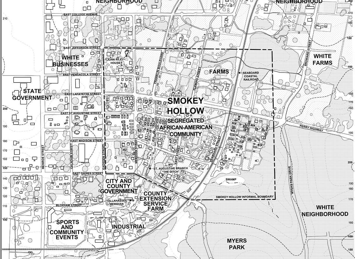
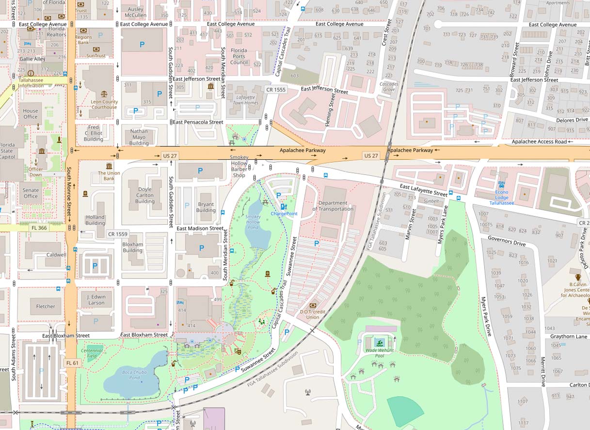
Contextual Plan of Smokey Hollow from 1938, Overlaid on a Current Map of Tallahassee

Comments
Join the conversation
Sign in or create an account to share your thoughts